
MÉRIDA.- Quite busy days are coming for the region, at least in meteorological matters, said the meteorologist Juan Antonio Palma.
On the one hand, significant rains will continue, at least until mid-week, in addition to the fact that tropical activity has finally begun in earnest over the waters of the Caribbean Sea.
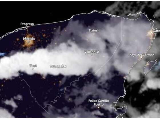
This is the forecast for the week of October 20 to 24 in Yucatán.
Tropical wave and ‘Mayan trough’ will bring rain to the Yucatan Peninsula
Starting tomorrow, Tuesday, the influence of another tropical wave will be recorded that, in combination with the “Mayan Vaguada”, will give way to the development of storms in several areas of the Yucatan Peninsula.
The onda tropical It will continue its advance towards the southeast of Mexico and the Pacific Ocean on Wednesday, however, the trail of humidity left, in continuous interaction with the “Mayan Vaguada”, will once again favor rains in the region.
Subsequently, the entry of drier air, driven by an anticyclone over the gulf of mexico will favor a decrease, both in intensity and distribution, of precipitation during the course of Thursday.
In this context, the forecasts indicate that on Tuesday and Wednesday there will be scattered moderate rains (5 to 25 mm) in 40% to 50% of Yucatan, Campeche y Quintana Roowith possible strong storms (25 to 50 mm), at least occasionally.
Then, for Thursday, the rains will become somewhat more limited and will be concentrated towards the central and southern portion of the peninsular territory.
Although accumulations of rain are not estimated to be as significant as on other occasions, we suggest that you continue to take extreme precautions in the face of the threat of abundant electrical activity and squalls in places with storms.
Heat and temperatures of more than 30° despite rain
Although he autumn continues to advance, the daytime heat will still be perceived significantly, since in the next three days maximum temperatures of 30 °C to 36 °C are expected at the peninsular level.
For its part, the predominant winds will be from the northeast, with intensities of 10 to 40 km/h, without ruling out gusts exceeding 45 km/h in coastal areas.
They monitor possible training of Melissa in the Caribbean
It is important to highlight that, in the coming days, we must remain very attentive to the evolution of tropical disturbance 98L, which is already over Caribbean waters.
To date, there is no clear forecast consensus related to the trajectory and intensity of this phenomenon due to the influence of several frontal systems and anticyclones over the Gulf of Mexico and the northern Caribbean Sea.
Everything seems to indicate that the disturbance will be, in the short term, very close to countries like Cuba, Jamaica, Haiti y Dominican Republicwhere they must be prepared, if necessary.
If the disturbance reaches tropical storm status, it will be named as “Melissa”.
✈️ Hurricane hunting plane approaches the area of instability with cyclonic potential. pic.twitter.com/6baok4fHJt
— Yucatan Meteorology (@ClimaYucatan) October 20, 2025
For now, The system is not a threat in the short term for the Yucatan Peninsulabut we had better also continue to closely monitor its development, in order to avoid surprises.
*Collaboration of Juan Antonio Palma