
One of the main myths surrounding the roman roadsand which has been extended by Hollywood films or comics Asterix and Obelixis that they were all stone paved and they showed off the characteristic slabs that can be seen in cities like Mérida or Pompeii. False: Interurban roads were built with rammed earthwhich turned them into porous and fine-grained paths.
Ancient Rome created a vast network of roads—more than 300,000 kilometers, according to experts—to unite large cities and smaller settlements and ephemeral roads that facilitated the movement and supply of the legions in their military campaigns.
The longest road in the entire Roman Empire was located in Hispania and was the Via Augusta, which extended from Spouses (Cádiz) until High Pyreneesin the Catalan Pyrenees. Its 1,500 kilometers connected Baetica with the north of the Iberian Peninsula bordering the Mediterranean and ultimately led to Rome. Although various identifiers have survived that indicate its route and the A-7 motorway and other national roads follow the same route in some sections, the same thing happens to this Roman road as to the vast majority: They have been destroyed over time.
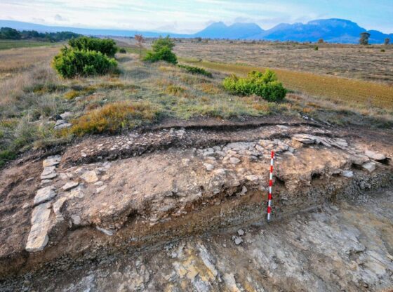
Prospecting of the Roman road that goes from Castro Urdiales to Osma de Álava in Lastras de Torre.
What could be said to be the best preserved Roman road in Hispania? The main candidate for this title, according to the researcher and civil engineer Isaac Moreno Gallo, an expert in the road network of the Caesar civilization, would be a highway of 115 kilometers long that communicated in Antiquity, about two millennia ago, the settlements of Flaviobriga (Castro Urdiales), a colony founded by Emperor Vespasian in 74 AD, and Uxama Barca (Osma de Álava), from where you could access other important centers such as Velia o Degobriga.
The road, which extends through four modern Spanish provinces, especially Burgos, circumvented the orography of the region, running through valleys like those of Losa and Mena to enter the Llanada Alavesa. On its route it also linked other Roman centers around the Burgos towns of San Llorente and San Martín de Losa, as well as the site of Salinas de Rosío, a salt mining city in ancient times with an unknown name.
In the area of the Losa valley it is precisely preserved an intact stretch of more than 1,600 continuous meters that have not undergone any transformation by heavy machinery and that has not been hidden by vegetation. The long embankment, located between Quincoces de Yuso, Castresana and Villaventín and about 6.35 meters wide, has avoided the agricultural works that destroyed other parts of the old road in the last decades of the last century and is casually preserved in a very good condition.
The archaeological tastings carried out in some sectors of the unplowed path free of vegetation, such as in Villaventín, near the border with Castresana, have revealed that the ancient Romans placed on the virgin rock a stone package almost a meter high and they added curbs to fit the foundation. The rectilinear layout and the materials used would have allowed its transit during all times of the year, also during times of heavy rain or snowfall. In the Lastras de Torre area, excavations have also made it possible to document the complete structure of the pavement.
In the Losa valley, in addition to the embankment, you can follow one of the longest aerial trails in the entire region of the already carved Roman road, with more than three uninterrupted kilometers in which the stone from the old road surface—sometimes used as the boundary of the farms—stands out for its color on the soil of the crop fields. Some fascinating vestiges of Roman Hispania.