
Scientists view volcanoes as powerful geological phenomena that leave a profound imprint on the climate by temporarily cooling the planet due to the clouds they release that block the sunlight reaching the Earth’s surface.
When a large volcano erupts, it releases huge amounts of sulfur dioxide into the upper atmosphere. There, this gas reacts with water vapor and turns into fine sulfate particles.
These particles act as small mirrors that reflect a large portion of the sun’s rays back into space, resulting in a decrease in the amount of solar energy reaching the Earth’s surface.
The result is noticeable surface cooling, which usually lasts from several months to two years, but… New study Published in the journal Nature Geoscience, it reveals that the influence of volcanoes goes beyond this mechanism, and its climate puzzle has been preserved for centuries.
Gabriele Villarini, a researcher in the Department of Civil and Environmental Engineering at Princeton University in the United States, and the corresponding researcher in the study, said in exclusive statements to Al Jazeera Net, “While the interest of most researchers was previously focused on the role of volcanic eruptions and their impact on climate variables such as temperature and precipitation, we have shown that these volcanic eruptions affect floods on a global scale as well. This is what we must take into account when evaluating “Risks.”
Volcanoes and floods are climate mysteries
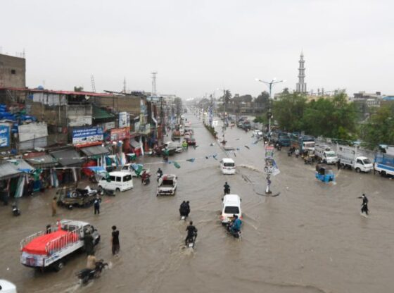
Floods are one of the most devastating and widespread natural disasters in the world, affecting millions of people annually and causing enormous economic losses.
Although floods result from a complex interaction between topography, urbanization, and weather, the main factors behind most floods are the amount of rainfall and temperature, which affect soil saturation, snowmelt, and water runoff on the Earth’s surface.
The new study raises a fundamental question about the ability of volcanoes to cool the planet and change the distribution of rainfall, and can they directly affect the intensity and location of floods?
To answer this, the team analyzed data from more than 7,800 river drainage measuring stations around the world, and combined it with high-resolution climate simulations using a comprehensive climate model developed by researchers at Princeton University to study and predict climate.
The researchers relied on this accurate statistical model that predicts peak river discharge in each season, based on average rainfall and temperature in the water basins. They then applied this model to a climate simulation that included three major volcanic eruptions in the twentieth century.
The three volcanoes are the 1963 Agung volcano in Indonesia, whose ash spread throughout the southern hemisphere, the 1902 Santa Maria volcano in Guatemala, whose ash spread was concentrated in the northern hemisphere, and the 1991 Pinatubo volcano in the Philippines, whose ash spread symmetrically between the two hemispheres.
This diversity allowed researchers to compare the effects of revolutions that are concentrated in one hemisphere versus those that affect both hemispheres.

Contradiction between the two halves of the Earth
The results showed that tropical regions were the most responsive to volcanic eruptions, as the intensity of floods decreased in the hemisphere in which the eruption occurred, and increased in the other hemisphere.
In the case of the Agung eruption, for example, the proportion of measuring stations recording a decrease in flood peaks in the Southern Hemisphere increased by about 25% in the first year after the eruption, while the Northern Hemisphere saw a gradual increase in flood peaks reaching 20% by the third year.
These patterns were not a coincidence, but were accompanied by a major shift in the position of the tropical rain belt known as the intertropical convergence zone, which is the most important rainfall system on Earth.
“Due to the increasing temperature differences between the two hemispheres as a result of volcanic force, flow across the equator transports moist air from one hemisphere to the monsoon regions, enhancing precipitation in the opposite hemisphere,” Villarini explains. This explains the discrepancy between the two halves of the Earth.
He added, “This large temperature difference between the two hemispheres moves the convergence zone between the two orbits away from the hemisphere in which the volcanic eruption occurred, leading to more rainfall in the opposite hemisphere.”
But when volcanic ash covered both hemispheres, as happened with the 1991 Pinatubo eruption, a very different response emerged. The study suggests that tropical precipitation declined in both hemispheres, resulting in widespread flooding rather than simply shifting it from one hemisphere to the other.
“This is due to the mechanism of coupling the monsoon winds to the desert,” says Villarini. “When the upward movement of air over the monsoon areas weakens as a result of the eruption, it causes the air to descend over the neighboring arid areas, increasing the rain there.”
In other words, the global landscape is becoming more complex, with dry regions receiving more rain and floods, while densely populated tropical regions experience temporary drought.

The accused is “temporarily” innocent!
This study has profound implications for our understanding of climate risks. At a time when most disaster management plans focus on floods resulting from anthropogenic climate change, the study reveals that nature itself is capable of suddenly reshaping the risk map, through a single massive volcanic event, with environmentally destructive human activity becoming a temporarily innocent accused.
The findings also raise important questions about geoengineering plans that propose pumping particles into the atmosphere to cool the planet and combat global warming. “Our work suggests that there are impacts that extend beyond just changes in temperature and precipitation,” Villarini says.
This means that any artificial intervention to cool the planet could lead to unexpected changes in flood and drought patterns.
“I would say that one of the most surprising findings was related to the effect of different volcanic cloud properties on flooding on a global scale,” he adds. That is, the extent to which the characteristics of the volcanic cloud itself, such as the size of particles and their distribution between the hemispheres, affects the shape of floods at the global level.
This means that the readiness of flood monitoring networks to monitor sudden changes after any major volcanic eruption is essential. According to researchers, the intensity of floods can change dramatically for several consecutive years after an eruption, which could increase losses if preventive measures are not taken. The study also recommends incorporating volcano data into flood early warning models, especially in tropical and seasonal regions that have proven to be the most sensitive to such disturbances.