
The Tormenta Tropical “Melissa” could become a major hurricane (4/5), and also drastically changed his trajectory: the new route heads towards Central America.
According to information provided by meteorologist Juan Antonio Palma Solís, “Melissa”He heads towards the West and could reach category 4 or 5 during the beginning of next week.
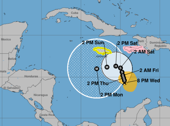
According to the report issued Yucatan Civil Protection During the afternoon of this Wednesday the tropical storm was located 1,585 kilometers southeast of the Yucatan Peninsulamoving west-northwest at 4 kilometers per hour. “Melissa” had sustained winds of 85 kilometers per hour, with gusts of 105 kph.
The United States National Hurricane Center indicated that the meteor will continue with its translation towards the West-Northwest during the following days.
However, according to predictions, for the Saturday 25when it is expected that “Melissa” evolves from tropical storm hurricanewould advance towards the West due to the influence of a anticyclone that will spread in the area, which is why the meteorological phenomenon will make a curve in that direction: that is, it would no longer point to the Greater Antilles but to Central America.
According to the data Procivy shared, the domingo 26 at noon “Melissa” will intensify to category 3 hurricane (with sustained winds of 178 to 208 Kph) and by Monday afternoon it would reach category 4 (with winds of 209 to 251 kph and higher gusts), because its movement will be over warm waters, which will increase its intensity.
✈️ Teamwork!!
NOAA and US Air Force hurricane hunter planes are simultaneously investigating #Melissa
We will see how much information they give us. pic.twitter.com/N837fiW4k5
— Yucatan Meteorology (@ClimaYucatan) October 22, 2025
The tropical storm dropped heavy rain on parts of Haiti y Dominican Republicas forecasters warn of a significant risk of flooding for several parts of the northern Caribbean throughout the week.