
In Yucatán, the culture of prevention against natural disasters is part of collective responsibility. This has allowed the population and authorities to react in advance to any catastrophe.
The consequences of hurricanes like “Isidoro” and “Gilberto” have greatly contributed to the roots of this culture in Yucatecan society, which remains in the collective memory of several generations.
“Yucatán is a national example of the culture of prevention,” said meteorologist Juan Palma Solís.
The specialist explained that the peninsula has an extensive infrastructure for measuring rainfall and tropical cyclones that includes meteorological stations distributed throughout the region, two radars, balloon probes and a meteorological buoy in front of Quintana Roo, which allows the winds to be detected in advance in the event of the approach of a cyclone.
“We are completely covered with sensors,” said the specialist, who stressed that, as a complement to technology, “people already have the culture of prevention. When the alert sounds, they prepare and abide by what the authorities say.”
Regarding what happened in Veracruz, Palma Solís clarified that the projections are based on numerical prediction models, which are used by meteorologists from all over the world, adjusted by specialists according to the conditions of the terrain and atmospheric systems.
Likewise, he stressed that official organizations “do not make direct measurements of rainfall,” but rather estimates based on predictive models.
“With these models, it is determined how much rain could fall in a certain area and based on that, warnings are issued. In this case, torrential rains were predicted and even possible extraordinary rainfall, which finally occurred.”
The rains, he added, are classified into intensity thresholds: light rains of up to 5 millimeters (mm); moderate, 5 to 25 mm; the strong ones report between 25 and 50 mm, causing flooding; the very strong ones are 50 to 75 mm, with the possibility of local damage; the intense ones are 75 to 100 mm”.
“Torrential storms can be greater than 100 millimeters, being capable of generating overflows and severe flooding, and extraordinary ones exceeding 150 mm.”
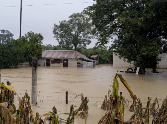
In Veracruz, rainfall exceeded 250 mm in less than 24 hours, which caused drainage systems to collapse and rivers to overflow. This added to the fact that during the days it rained, 600 mm accumulated.
According to the expert, “they are the most intense that has ever been in Mexico.”
The specialist explained that the magnitude of the disaster was not due to a meteorological warning error, but rather to a combination of several factors.
“The Meteorological Service warned in advance; however, the evacuation and emergency protocols correspond to Civil Protection and the government.”
Unlikely scenario
When asked if this situation could occur in the state, Palma Solís was very clear when mentioning that our geographical composition is different from that of the states that have experienced floods throughout history.
“In Yucatán it would be very difficult for something like this to happen for a simple reason: we do not have large rivers or mountainous areas where water can accumulate or flow down strongly towards the towns,” he explained.
Sometimes, part of the population does not comply with the instructions due to lack of knowledge or distrust in the technical bulletins.
“We don’t need a category 5 hurricane to have a tragedy. This low pressure had only 10% cyclonic potential, but it was loaded with water. Sometimes people see that and think that nothing is happening,” he explained.
Even so, he recalled that the risk of flooding due to soil saturation remains high, as in 2020 with “Cristóbal”, which left continuous rains for several days.
“That didn’t happen in a single day, but for weeks. In Veracruz everything fell in a matter of hours. They are different scenarios.”
Palma Solís insisted that beyond technical data, meteorological information must be communicated in a language accessible to everyone.
“It is not enough to say ‘torrential rains’ or ‘cyclonic potential’. You have to explain to people what that means in their daily lives. Nature cannot be avoided, but it can be anticipated and prepared. If the information is given, the next step is to act.”— Karla Cecilia Acosta Castillo
Climate Methodology
Meteorologist Juan Antonio Palma Solís mentions part of the rainfall classification.
Classification
Rainfall is classified into intensity thresholds: light rain of up to 5 millimeters; moderate, 5 to 25 millimeters (mm); the strong ones report between 25 and 50 mm, causing flooding; the very strong ones are 50 to 75 mm, with the possibility of local damage; the intense ones are 75 to 100 mm; The torrential ones can be greater than 100 mm, being capable of generating overflows and severe flooding, and the extraordinary ones that exceed 150 mm.
Notices
“With the models, it is determined how much rain could fall in a certain area and based on that, warnings are issued,” says the specialist.