
The focus of attention of the meteorological centers continues on the tropical storm “Melissa”, which maintains an erratic trajectory.
In the statement issued by the National Oceanic and Atmospheric Administration (NOAA) at 8 pm (local time) it was reported that the maximum sustained winds are 75 kph, its speed of movement remains at 4 kph and its trajectory continues to indicate a trend towards the north-northwest.
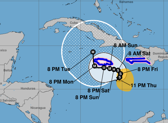
The report indicated that a sharp turn to the west could occur by the weekend. The tropical storm is projected to move closer to Jamaica and the southwestern portion of Haiti over the next two days.
Additionally, gradual strengthening was forecast, followed by rapid intensification this weekend.
Juan Antonio Palma Solís, meteorology specialist, pointed out that “Melissa” will remain stationary in the southeast of Jamaica the day after tomorrow, Saturday, and will become a category four or five hurricane. By next Monday it would begin to move little by little north again, coinciding with the arrival of a cold front.
Yucatán Civil Protection (Procivy), announced in its afternoon statement that the storm is located 1,378 km southeast of the state. He stressed that he still does not represent a threat to Yucatán.
The speed at which it moves continues to be slow and its location of great importance, so monitoring is maintained for at least five more days.
Meteorologist Palma Solís explained again that the reason why “Melissa” is moving at that speed is because it is “trapped” between two anticyclones. One located over the Lesser Antilles – an arc of volcanic islands, located in the eastern part of the Caribbean Sea – and the other over the Gulf of Mexico.
In his analysis, he stated that the trend in the movement of “Melissa” would be towards the north, but the trajectory will depend on the strength of the prevailing anticyclone.
The specialist clarified that there is still the possibility that the predictions do not occur as proposed, since as always mentioned, they are only forecasts. Given this, the population was invited to stay informed through official media.— KARLA ACOSTA CASTILLO
Scenarios
There are two possible scenarios, according to meteorologist Juan Antonio Palma Solís. “If the Lesser Anticyclone develops and expands, the movement would be towards the northwest, approaching Jamaica and Cuba. If the Gulf anticyclone extends towards the western Caribbean we would see a change towards the northeast, directing it towards Haiti.”
However, he clarified that there is a possibility that the predictions do not occur.